This was a very different summer Oregon trip for us. Dad entered a National Bowling Tournament in Billings, Montana, with my brother, and he asked us to ride along with him. So we did---making DH, Ken, drive, of course. It was fun seeing a totally different part of the USA. We made it a touring trip, stopping at many places along the way. Even some new places for us in Oregon!
Not new to us, but along the way is the Historic Columbia River Highway. I-84 would have been quicker, but if I have the choice of a scenic drive, I'd much rather take it. The Historic Columbia River Highway is an approximately 75 mile scenic highway in Oregon built through the Columbia River Gorge between 1913 and 1922. It is the first planned scenic roadway in the United States. There are many pull outs and viewpoints along the way.
Here are just a few of them:
View of the Vista House from the Portland Women's Forum State Park viewpoint.
Vista House is an observatory at Crown Point in Multnomah County. It serves as a memorial to Oregon pioneers and as a viewpoint for travelers on the Historic Columbia River Highway. It was completed in 1918. When we were there, it was fenced off for restorations which ended up taking 5 years.

But we were still able to get a nice view from there of the Columbia River gorge. This was looking east with Washington State on the other side of the Columbia River.

There are also lots of waterfalls near this highway. We even stopped at a couple of them.
Wahkeena Falls is about 13 miles east of Troutdale. A short hike uphill from the parking lot at the base leads to a stone bridge that crosses the main part of the falls. That trail continues on east to Multnomah Falls, the next falls down the road.

Multnomah Falls is the tallest waterfall in Oregon at about 620 feet. Unlike the other falls along the Gorge, the Multnomah area is also reachable from I-84. There is even a lodge there (which I don't seem to have a picture of from this trip) which was completed in 1925 and is now on the US National Register of Historic Places-- Multnomah Falls Lodge.

A foot trail leads to Benson Footbridge, a 45-foot long footbridge that allows visitors to cross 105 feet above the lower cascade. The trail continues to a platform at the top of the upper falls where visitors get a bird's-eye view of the Columbia Gorge and also of "Little Multnomah", a small cascade slightly upstream from the "upper" falls which isn't visible from ground level. We also like to take the path down to the pool at the lower falls.


Visitors may view inside a powerhouse and get underwater views of salmon as they swim past windows in the fish ladder.


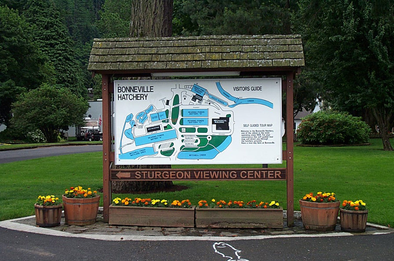
the spawning room

The hatchery building

Fish leading the self guided tour.

Looking towards the trout viewing pond.

The sturgeon viewing building

Another view of the sturgeon viewing area.

Trout pond.

The gift shop.

Enough touring for now. It was time to hit the road and get to Montana. It was a nice ride and the tournament was well attended. I don't remember how the guys did, but I know they had fun.
Dad near the entrance to the bowling facility.

Here come the bowlers.

Good luck, Dad!!!

When bowling was done, we did a little more touring. Little Bighorn Battlefield National Monument wasn't far, so we went to check it out. Hard to believe we were standing where so many died on June 25 and 26 of 1876! This area memorializes the U.S. Army's 7th Cavalry and the Sioux and Cheyenne in one of the Indian's last armed efforts to preserve their way of life.

The Battle of the Little Bighorn was fought along the ridges, steep bluffs, and ravines of the Little Bighorn River.


Custer's grave - lower right.


There was construction going on for an Indian Memorial while we were there.


We also stopped at Pictograph Cave---a 23-acre area of three caves located about 5 miles from Billings. Excavation of the three caves began in 1937, and they were the site of some of Montana's first professional archeological studies. Over 30,000 artifacts have been identified, with at least 20,000 animal remains recovered from the site. The pictographs are more than 2,100 years old. However their interpretations are still debated over.
View near the cave.

Distant view of the caves.

By the trail to the cave.

In the cave.

On our way back to Oregon, we detoured down to Yellowstone National Park and spent a couple nights there. I had been here once before when I was about 5 years old and I all really remembered was being scared all night. This time I enjoyed it so much more!
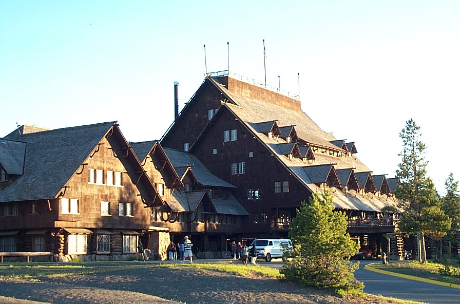
I booked us a room in Old Faithful Inn. It was the first of the great park lodges of the American west and is one of the few log hotels still standing in the United States. The lobby and restaurant were massive.
The room was rather rustic, but that was part of it's charm.

We spent 2 days running around the park checking out the many very different areas. I have a separate blog of Yellowstone with lots of discriptions so I won't spend much time on it now. For full discriptions, check out : http://travelingwithsue.blogspot.com/2009/10/yellowstone-geological-wonder.html These are some of the pictures from it.
Yellowstone Lake


The Monument and Preserve encompass three major lava fields and about 400 square miles of sagebrush steppe grasslands to cover a total area of 1,117 square miles.

The Monument and Preserve contain more than 25 volcanic cones, including outstanding examples of spatter cones.

All three lava fields lie along the Great Rift of Idaho, with some of the best examples of open rift cracks in the world, including the deepest known on Earth at 800 feet.

It was also where our car had some very odd and spooky electrical problems! It went totally dead. Ken got it going again and we tried to check out more of the park, but it died again. After getting it going a couple more times, we vacated the area as fast as we could and never had that problem with the car again!
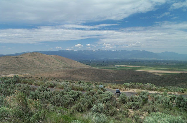
 Once we got back into Oregon, we came upon Baker City. Looked like it would have been fun to check out the 42 acre Historic District with it's more then 130 properties in the center of town, but we just made it to The National Historic Oregon Trail Interpretive Center. It is actually about 5 miles east of the city and has lots of exhibits, theater performances, workshops, and other events and activities related to the Oregon Trail.


Grand Canyon Artists Point

Black Pool

Upper Geyser Basin by Old Faithful

Old Faithful!

Dragon Spring mud volcano

Minerva Terrace in the Mammoth Hot Springs area

Paint Pot mud pots

Opalescent Pool in Black Sand Basin

West Thumb Geyser area

wildlife throughout the park

Even a bear

And more gorgeous scenery from the car

Back on the road to Oregon we also went through an interesting Park in Idaho---Craters of the Moon National Monument and Preserve. The protected area is volcanic and represent one of the best-preserved flood basalt areas in the continental United States.
The visitors' center.

The Monument and Preserve encompass three major lava fields and about 400 square miles of sagebrush steppe grasslands to cover a total area of 1,117 square miles.

The Monument and Preserve contain more than 25 volcanic cones, including outstanding examples of spatter cones.

All three lava fields lie along the Great Rift of Idaho, with some of the best examples of open rift cracks in the world, including the deepest known on Earth at 800 feet.

It was also where our car had some very odd and spooky electrical problems! It went totally dead. Ken got it going again and we tried to check out more of the park, but it died again. After getting it going a couple more times, we vacated the area as fast as we could and never had that problem with the car again!


The view from the center was impressive.


Of course they had lots of stagecoaches


Even the ruts of the original stagecoaches traveling the Oregon Trail can still be seen here running through the center of this 500 acre site.

From there we pretty much headed straight back to Dallas, Oregon (just west of Salem).
But our vacation wasn't over yet! We still had a couple days left. So we did make it up into the Cascades to do some more sightseeing and fishing. We usually end up at Clear Lake, but this time settled for Detroit Lake.


It was another fantastic Oregon vacation---with a twist. I had originally dreaded the long ride, but ended up really enjoying it! I have since hoped we would be able to do some more of these journeys from Oregon. I guess there's still hope yet!
No comments:
Post a Comment